Spearhead Extended Lingevres: Difference between revisions
Category: SPEX - Spearhead Extended
(Created page with "Category: SPEX - Spearhead Extended") |
m (→Statistics: updated coordinates) |
||
| (2 intermediate revisions by the same user not shown) | |||
| Line 1: | Line 1: | ||
{{TOC|side}} | |||
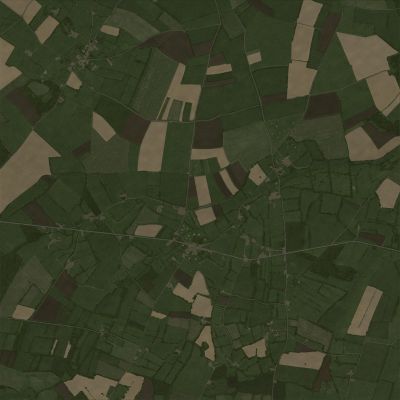
[[File:spex_lingevres_picturemap_ca.jpg|400px|right|Satellite Image|thumb]] | |||
This British sector terrain, designed in 1:1 scale, captures the rugged terrain and strategic significance of this fierce battleground in the Normandy breakthrough. Key locations, including the war-torn village of Lingevres, the surrounding bocage, fortified German positions, and the distinctive orchard fields, are brought to life in stunning detail. | |||
Be ready to navigate dense hedgerows, maneuver through the intricate network of orchard fields, and engage in intense close-quarters combat within the village. The abundance of micro vegetation adds depth to the battlefield, providing natural concealment and tactical opportunities. | |||
= Statistics = | |||
{| class="wikitable" | |||
|- | |||
| Size || 4 km x 4 km | |||
|- | |||
| Area || 16 km<sup>2</sup> | |||
|- | |||
| Coordinates || 49°10'33.0" North<br/> | |||
0°40'24.4" West | |||
|- | |||
| Object Count || | |||
{{Columns|1| | |||
* '''TOTAL:''' 155912 | |||
* BUILDING: 231 | |||
* BUNKER: 29 | |||
* BUSH: 63032 | |||
* CHURCH: 2 | |||
* FENCE: 11920 | |||
* FORTRESS: 34 | |||
* FOUNTAIN: 79 | |||
* HIDE: 22012 | |||
* HOUSE: 923 | |||
* ROAD: 662 | |||
* ROCK: 3 | |||
* TRACK: 1367 | |||
* TREE: 52963 | |||
* WALL: 2652 | |||
* WATERTOWER: 3 | |||
}} | |||
|} | |||
= High Resolution Map = | |||
A high resolution .svg can be downloaded {{Link/External|link=https://drive.google.com/drive/folders/19pnqIXrccqvsDbbo12YoWTfM1IMBStik?usp=sharing|text=here}} | |||
[[Category: SPEX - Spearhead Extended]] | [[Category: SPEX - Spearhead Extended]] | ||
Latest revision as of 17:57, 21 July 2025
This British sector terrain, designed in 1:1 scale, captures the rugged terrain and strategic significance of this fierce battleground in the Normandy breakthrough. Key locations, including the war-torn village of Lingevres, the surrounding bocage, fortified German positions, and the distinctive orchard fields, are brought to life in stunning detail.
Be ready to navigate dense hedgerows, maneuver through the intricate network of orchard fields, and engage in intense close-quarters combat within the village. The abundance of micro vegetation adds depth to the battlefield, providing natural concealment and tactical opportunities.
Statistics
| Size | 4 km x 4 km |
| Area | 16 km2 |
| Coordinates | 49°10'33.0" North 0°40'24.4" West |
| Object Count |
|
High Resolution Map
A high resolution .svg can be downloaded here

