Terrain Processor: Area: High-density Cluster: Difference between revisions
Lou Montana (talk | contribs) m (Text replacement - " *\|= " to " ") |
Lou Montana (talk | contribs) m (Text replacement - "[[Image:" to "[[File:") |
||
| Line 48: | Line 48: | ||
| 2 | | 2 | ||
| 1 | | 1 | ||
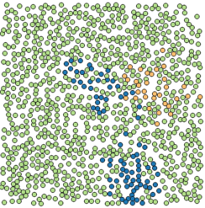
| [[ | | [[File:TerrainProcessor_HightFrag1.png]] | ||
|- style="vertical-align:top;" | |- style="vertical-align:top;" | ||
| 2 | | 2 | ||
| Line 54: | Line 54: | ||
| 4 | | 4 | ||
| 2 | | 2 | ||
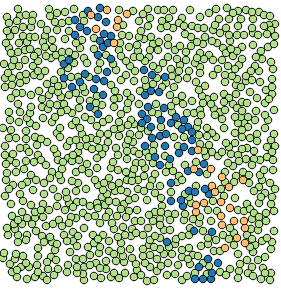
| [[ | | [[File:TerrainProcessor_HightFrag2.png]] | ||
|- style="vertical-align:top;" | |- style="vertical-align:top;" | ||
| 5 | | 5 | ||
| Line 60: | Line 60: | ||
| 10 | | 10 | ||
| 5 | | 5 | ||
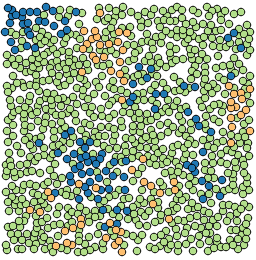
| [[ | | [[File:TerrainProcessor_HightFrag3.png]] | ||
|} | |} | ||
Legend: [[ | Legend: [[File:TerrainProcessor_HightFragLegend.png]] | ||
Latest revision as of 23:11, 20 November 2023
Task details
Task name : Area: Hight-density Cluster
Dll plugin name : BITasksPlugin.dll
Geometry type : Polygon, PolygonM, PolygonZ
Heightmap : No
Description
Random placement of multiple objects inside the polygons specified in the given shapefile. First step is to create lifegrid. Lifegrid is 2D table where every cell has information about its Object prototype. Algorithm puts some first seeds. Counts and types of seeds depends on input parameters. Ideal for high density areas like forest.
Example
- Spruce 85% PROB
- Pine 10% PROB
- Larch 5% PROB
See the bottom of the page for the data from the example.
Task parameters
- Random seed - number used to initialize pseudorandom number generator.
- Hectare density - density of the filling, in number of objects for hectare. For example 100 objects per hectare means an average distance of 10 meters between each object.
- Fraction - initial seeds count for smallest probability object prototype on hectare.
- Blend distance - distance to get object prototype.
Object prototype parameters
- OBJECT - Object's prototype name
- PROB - Object's probability
- MINHEIGHT - Minimal size in %
- MAXHEIGHT - Maximal size in %
- MINDIST - Minimal distance in meters
Usage
Use for areas with high objects density, where particular object types tend to aggregate in groups, e.g. in mixed forests.
Algorithm
For each shape (areal) do :
- Create and populate "lifegrid"
- Find shape bounding.
- Create empty "lifegrid" for this area.
- Generate base seeds (for each object prototype)
- seeds_count = HECTARES * CDENSHA
- Randomly generate seeds_count in shape and set this grid item prototype.
- instances_count = HECTARES * DENSHA
- For instances_count try to find position :
- Random position in bounding box.
- If position is inside shape, continue to c. else a.
- Test with objects if minimal distance is ok, continue to d. else a.
- Find object prototype - random grid item in radius 50 meters. This grid item has information about object prototype.
If this loop a <-> d has no new output for last 100 attempts, area is full and iteration of this shape will end.
Example data
| Fragmentation | Spruce seeds count | Pine seeds count | Larch seeds count | Preview |
|---|---|---|---|---|
| 1 | 17 | 2 | 1 | 
|
| 2 | 34 | 4 | 2 | 
|
| 5 | 85 | 10 | 5 | 
|

