From Bohemia Interactive Community
Hover & click on the images for description
Description
- Description:
-
Like the old TOPOGRAPHY cheat code, exports terrain, but in modern SVG format instead of the proprietary EMF format.
- Groups:
- Diagnostic
Syntax
- Syntax:
- diag_exportTerrainSVG [filePath, drawLocationNames, drawGrid, drawCountlines, drawTreeObjects, drawMountainHeightpoints, simpleRoads]
- Parameters:
- filePath: String - path on disk. File name and extension have to be included
- drawLocationNames: Boolean - whether or not to draw location names
- drawGrid: Boolean - whether or not to draw grid
- drawCountlines: Boolean - whether or not to count lines
- drawTreeObjects: Boolean - whether or not to draw trees
- drawMountainHeightpoints: Boolean - whether or not to draw mountain height spots
- simpleRoads: Boolean - simplify roads. Draw roads as one long polyline instead of separate segments. Uses average road width as overall width
- Return Value:
- Nothing
Examples
- Example 1:
Additional Information
- See also:
- Arma 3: Diagnostics Exe
Notes
-
Report bugs on the Feedback Tracker and/or discuss them on the Arma Discord.
Only post proven facts here!
Add Note

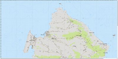 Highly detailed map of Stratis