
diag exportTerrainSVG: Difference between revisions
Lou Montana (talk | contribs) m (Text replacement - "\|game([0-9]) ?= (.+) \|version([0-9]) ?= (.+) " to "|game$1= $2 |version$3= $4 ") |
Lou Montana (talk | contribs) m (Text replacement - "(\|[pr][0-9]+ *= *[^- ]*) *- *W([a-z ])" to "$1 - w$2") |
||
| (6 intermediate revisions by 2 users not shown) | |||
| Line 1: | Line 1: | ||
{{RV|type=command | {{RV|type=command | ||
|game1= | |game1= arma3 | ||
|branch= diag | |||
|version1= 2.02 | |version1= 2.02 | ||
|gr1= Diagnostic | |gr1= Diagnostic | ||
|descr= [[File: A3 diag exportTerrainSVG Example.jpg|thumb|400px|Highly detailed map of [[Stratis]]|right]] | |||
Like the old [[Arma 3: Cheats#TOPOGRAPHY|TOPOGRAPHY]] cheat code, exports terrain, but in modern SVG format instead of the proprietary EMF format. | |||
|descr= [[File: A3 diag exportTerrainSVG Example.jpg|thumb | |||
Like the old [[ | |||
|s1= [[diag_exportTerrainSVG]] [filePath, drawLocationNames, drawGrid, drawCountlines, drawTreeObjects, drawMountainHeightpoints, simpleRoads] | |s1= [[diag_exportTerrainSVG]] [filePath, drawLocationNames, drawGrid, drawCountlines, drawTreeObjects, drawMountainHeightpoints, simpleRoads] | ||
|p1= filePath: [[String]] - | |p1= filePath: [[String]] - path on disk. File name and extension have to be included | ||
|p2= drawLocationNames: [[Boolean]] - | |p2= drawLocationNames: [[Boolean]] - whether or not to draw location names | ||
|p3= drawGrid: [[Boolean]] - | |p3= drawGrid: [[Boolean]] - whether or not to draw grid | ||
|p4= drawCountlines: [[Boolean]] - | |p4= drawCountlines: [[Boolean]] - whether or not to count lines | ||
|p5= drawTreeObjects: [[Boolean]] - | |p5= drawTreeObjects: [[Boolean]] - whether or not to draw trees | ||
|p6= drawMountainHeightpoints: [[Boolean]] - | |p6= drawMountainHeightpoints: [[Boolean]] - whether or not to draw mountain height spots | ||
|p7= simpleRoads: [[Boolean]] - | |p7= simpleRoads: [[Boolean]] - simplify roads. Draw roads as one long polyline instead of separate segments. Uses average road width as overall width | ||
|r1= [[Nothing]] | |r1= [[Nothing]] | ||
|x1= < | |x1= <sqf>diag_exportTerrainSVG ["C:\Users\USERNAME\Desktop\Stratis_Map.svg", true, true, true, true, true, false]; // replace USERNAME with your username!</sqf> | ||
|seealso= [[Arma 3: Diagnostics Exe]] | |seealso= [[Arma 3: Diagnostics Exe]] | ||
}} | }} | ||
Latest revision as of 16:35, 8 November 2023
Description
- Description:
- Like the old TOPOGRAPHY cheat code, exports terrain, but in modern SVG format instead of the proprietary EMF format.
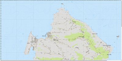 Highly detailed map of Stratis
 - Groups:
- Diagnostic

Syntax
- Syntax:
- diag_exportTerrainSVG [filePath, drawLocationNames, drawGrid, drawCountlines, drawTreeObjects, drawMountainHeightpoints, simpleRoads]
- Parameters:
- filePath: String - path on disk. File name and extension have to be included
- drawLocationNames: Boolean - whether or not to draw location names
- drawGrid: Boolean - whether or not to draw grid
- drawCountlines: Boolean - whether or not to count lines
- drawTreeObjects: Boolean - whether or not to draw trees
- drawMountainHeightpoints: Boolean - whether or not to draw mountain height spots
- simpleRoads: Boolean - simplify roads. Draw roads as one long polyline instead of separate segments. Uses average road width as overall width
- Return Value:
- Nothing
Examples
- Example 1:
Additional Information
- See also:
- Arma 3: Diagnostics Exe
Notes
-
Report bugs on the Feedback Tracker and/or discuss them on the Arma Discord.
Only post proven facts here! Add Note